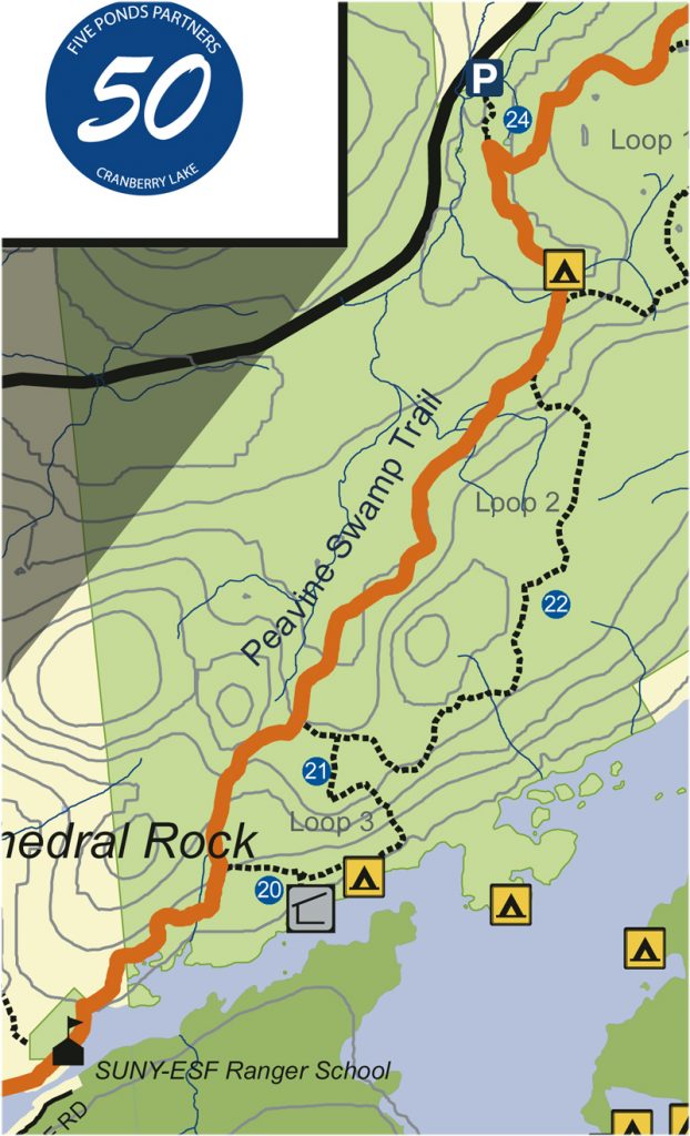
Peavine Swamp Trail
Peavine Swamp Trail
Hike 0.25 miles on Ranger School land to the State-land boundary (Cranberry Lake Wild Forest). Continue on this yellow-marked trail another 0.7 miles to intersection with Peavine Swamp Loop 3 trail. Bear left/north to follow the CL50 and the main trunk of the Peavine trail. A turn right here will take you to a lean-to campsite along the river, a 0.5 miles side trip. Follow the main trunk of the Peavine Swamp Trail as it tracks northeast through late-successional forest. Along the way you will pass junctions (on your right) for the Peavine Swamp side loops 3, 2 and 1 (designed as cross-country ski loops). You will pass a campsite on your right at 2.9 miles, and beyond that, at 3.7 miles from the initial Loop 3 intersection described above, you will reach an intersection with Peavine Swamp Loop 1 trail.
Note that the NYS Route 3 parking area for the Peavine Swamp Trails is only 0.3 miles further north.
To continue on the CL50, turn right, following Peavine Swamp Loop 1 trail for 0.9 miles. Now turn left/north, following a newly constructed trail. Cross a wooden bridge and continue to State-land boundary at 0.8 miles from last junction. Continue straight, now crossing onto NYS Conservation Easement land (private land that the public has permission to use in this case). At 1.4 miles you will reach a parking area on the Columbian Road. This parking area is used by boaters as well as hikers.
Total distance from Ranger School to Columbian Road is 7.7 miles.
Download full map here
Get your Cranberry Lake 50 Hiker’s Map
Get your Cranberry Lake 50 Hiker’s Map contains an updated map and lots of information to help you plan your trip. Download here or get this waterproof, tear-proof map for $9.95 at the following locations:
Adirondack Mountain Club, Lake Placid and Lake George
Adirondack Hamlets to Huts, Saranac Lake
The Bookstore Plus, Lake Placid
Grass River Outfitters, Canton
Hoss’s Country Store, Long Lake
Birch’s Lakeside General Store
Campground, & Marina, Cranberry Lake
Otto’s Abode, Wanakena
Raquette River Outfitters, Tupper Lake
Sevey’s Point, Childwold
St. Lawrence Co. Chamber of Comm., Canton
St. Regis Outfitters, Saranac Lake
Stone Manor Diner/Motel, Cranberry Lake
The Mountaineer, Keene Valley
U-Bs Mercantile, Oswegatchie
Get your patch!
When you complete the entire loop let us know and we will add your name to our list of finishers!
Just want the patch? Send minimum $5 donation to FIVE PONDS PARTNERS, PO Box 183, Wanakena, NY 13695
Make checks payable to FIVE PONDS PARTNERS.