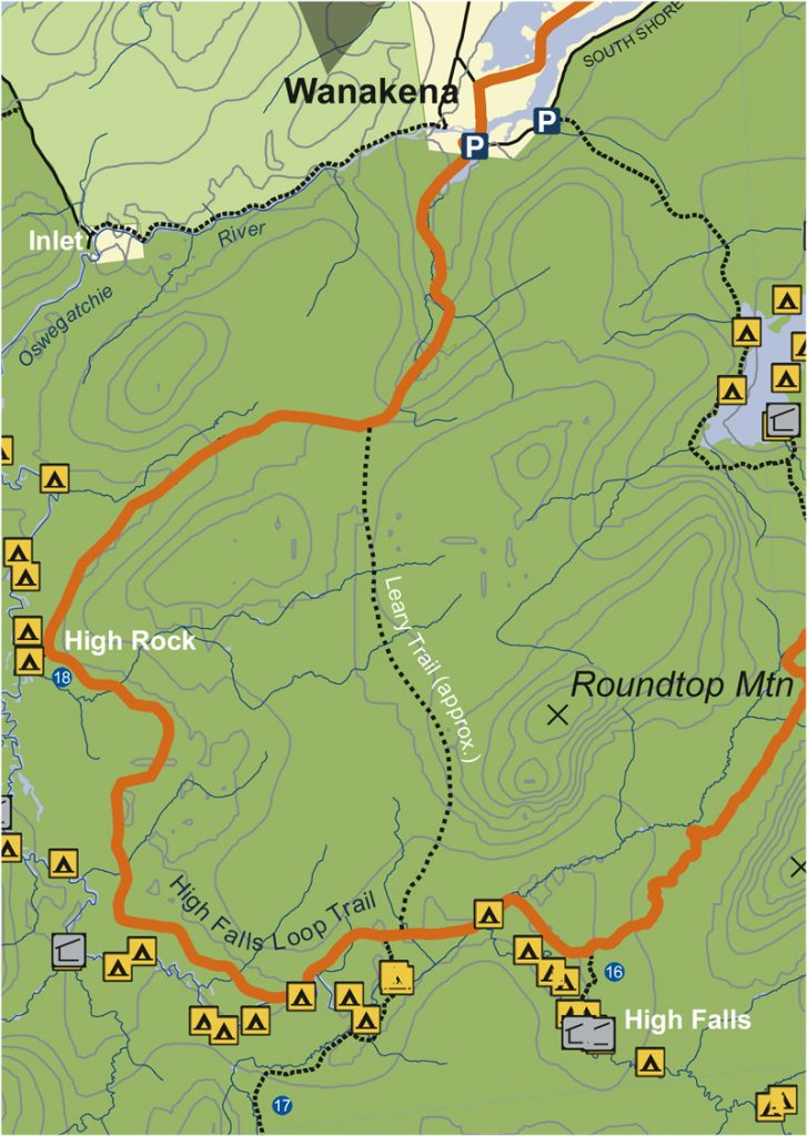
High Falls Loop
High Falls Loop Trail
This is a popular loop trail that begins and ends in Wanakena and offers about 15 miles of easy to moderate hiking that can be done in one day.
The CL50 leaves Sand Hill Junction and heads southwest on a red-marked trail towards High Falls. This section of the trail is often affected by beavers and may require a walk on a beaver dam or two before getting to the falls. However, the falls and the old growth white pines and yellow birch make the trip worthwhile. It is about 2.5 miles from Sand Hill Junction to the junction with the High Falls trail, although signs suggest it is 2.9 miles.
At the junction, turn left to visit the falls (0.4 miles) and lean-to campsites on either side of the Oswegatchie river. When returning from the falls to the trail intersection, bear left/west to continue following the CL50 in a clockwise direction.
At 1.2 miles you will pass a trail on your left/south that leads to the actual Five Ponds for which the wilderness area is named. The CL50 continues straight here (along an old logging railroad bed), following red markers.
Beaver reign supreme along this section of trail also, requiring you to cross at least a few (sometimes sketchy) dams.
Continuing another 3.5 miles from the Five Ponds junction, you will see side trail that leads left/west 0.2 miles to High Rock. High Rock offers an impressive view of the ‘Oswegatchie Oxbows” and a nice campsite. Continuing straight past the High Rock junction for about 4 miles, the trail loops north and east, crosses Skate Creek (where flooding is often an issue), and arrives at a DEC register and metal gate just south of the quaint trail-town of Wanakena.
Total distance from Sand Hill Junction to Wanakena is 11.2 miles (without side trips to falls, etc).
Download full map here
Get your Cranberry Lake 50 Hiker’s Map
Get your Cranberry Lake 50 Hiker’s Map contains an updated map and lots of information to help you plan your trip. Download here or get this waterproof, tear-proof map for $9.95 at the following locations:
Adirondack Mountain Club, Lake Placid and Lake George
Adirondack Hamlets to Huts, Saranac Lake
The Bookstore Plus, Lake Placid
Grass River Outfitters, Canton
Hoss’s Country Store, Long Lake
Birch’s Lakeside General Store
Campground, & Marina, Cranberry Lake
Otto’s Abode, Wanakena
Raquette River Outfitters, Tupper Lake
Sevey’s Point, Childwold
St. Lawrence Co. Chamber of Comm., Canton
St. Regis Outfitters, Saranac Lake
Stone Manor Diner/Motel, Cranberry Lake
The Mountaineer, Keene Valley
U-Bs Mercantile, Oswegatchie
Get your patch!
When you complete the entire loop let us know and we will add your name to our list of finishers!
Just want the patch? Send minimum $5 donation to FIVE PONDS PARTNERS, PO Box 183, Wanakena, NY 13695
Make checks payable to FIVE PONDS PARTNERS.