Cranberry Lake 50 Trails
Cranberry Lake 50 Trails
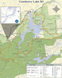
There is no official loop direction, but the majority of people hike clockwise around the lake. The elevation gain is, obviously, the same either way, but ascents tend to be more gradual when hiking in the clockwise direction. There are actually several places one could start/end the CL 50, and parking is available at each. Importantly, there is also a register at or near each of these trailheads and all hikers should sign in for their safety.
The following seven trailheads can be found on the Cranberry Lake 50 Trail Map:
- High Rock ‘truck trail’ trailhead on South Shore Road in Wanakena, NY
- Dead Creek Flow trailhead on South Shore Road in Wanakena, NY
- Peavine Swamp trailhead, located on NYS Route 3 west of Cranberry Lake, NY
- DEC boat launch trailhead on Columbian Road in Cranberry Lake, NY
- Cranberry Lake Community Center in Cranberry Lake, NY (behind center)
- Gilbert Tract trailhead, located on NYS Route 3 just east of Cranberry Lake, NY
- Burntbridge Pond/Brandy Brook trailhead, located on NYS Route 3 about two
miles east of Cranberry Lake, NY
For those with boat access, other options are available. For those with intermediate to advanced biking skills, keep in mind that several miles of the CL50 are open to biking. In fact, the Peavine Swamp Trail, the Gilbert Tract/Brandy Brook Trail and, of course, the sections of the CL50 that coincide with Route 3 and the Ranger School Road are all legally open to biking. No motorized or mechanized transportation is allowed in the Five Ponds Wilderness Area, including bikes.
Before you start your trip please download full Cranberry Lake 50 Trail Map here
TRAIL CONDITIONS AND TIME REQUIREMENTS
How long does it take to hike 50 miles? A 3-day, 2-night option is popular for the average hiker. Even if carrying a heavy pack, the well-marked, well-maintained, gently rolling trails facilitate steady progress. However, as you will see on the map, there are several possibilities for dividing the route into reasonable distances based on time available, interest, ability, season and preferred mode of travel (e.g, hike, bike, ski). Some people spread the adventure over several years, doing only one or two small sections a year. Some have completed the loop in less than 24 hours! However, no official speed records are maintained or celebrated; the primary purpose of trail is to provide a relaxing opportunity to reconnect with nature, friends,and one’s own physical and spiritual health. Your CL50 experience can be customized and enhanced by including one or more side trips (refer to CL50 Pocket Guide). These will surely require additional time beyond the typical 3-day trip, so be sure to plan accordingly.
Get your Cranberry Lake 50 Hiker’s Map
Get your Cranberry Lake 50 Hiker’s Map contains an updated map and lots of information to help you plan your trip. Download here or get this waterproof, tear-proof map for $9.95 at the following locations:
Adirondack Mountain Club, Lake Placid and Lake George
Adirondack Hamlets to Huts, Saranac Lake
The Bookstore Plus, Lake Placid
Grass River Outfitters, Canton
Hoss’s Country Store, Long Lake
Birch’s Lakeside General Store
Campground, & Marina, Cranberry Lake
Otto’s Abode, Wanakena
Raquette River Outfitters, Tupper Lake
Sevey’s Point, Childwold
St. Lawrence Co. Chamber of Comm., Canton
St. Regis Outfitters, Saranac Lake
Stone Manor Diner/Motel, Cranberry Lake
The Mountaineer, Keene Valley
U-Bs Mercantile, Oswegatchie
Get your patch!
When you complete the entire loop let us know and we will add your name to our list of finishers!
Just want the patch? Send minimum $5 donation to FIVE PONDS PARTNERS, PO Box 183, Wanakena, NY 13695
Make checks payable to FIVE PONDS PARTNERS.