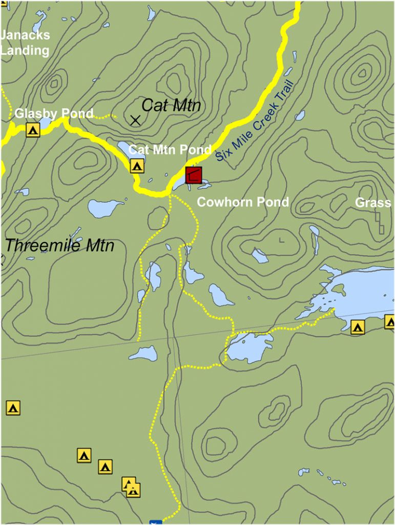
Cowhorn Junction Trail
Cowhorn Junction Trail
This 2-mile, yellow-marked trail travels westerly from Cowhorn Junction to Sand Hill Junction. As you approach Cat Mt Pond, you will see a trail leading right to a campsite along the shore of the pond. At just over a mile from Cowhorn Junction, a trail intersection is reached. Turn left (west) to continue to Sand Hill Junction or turn right (east) and ascend Cat Mountain for an excellent side trip. Turning left, the trail continues past Glasby Pond, through an often-used campsite next to the pond, to Sand Hill Junction in another 0.9 miles. At the Sand Hill Junction the CL50 turns left/southwest and begins the “High Falls Loop.” Note that one may turn right here, especially in an emergency, to reach the Janacks Landing lean-to on the lake (1.1 miles), and/or to continue on the red-marked Dead Creek Flow trail to Wanakena (3.5 miles total)
 See full map here
Get your Cranberry Lake 50 Hiker’s Map
Get your Cranberry Lake 50 Hiker’s Map contains an updated map and lots of information to help you plan your trip. Download here or get this waterproof, tear-proof map for $9.95 at the following locations:
Adirondack Mountain Club, Lake Placid and Lake George
Adirondack Hamlets to Huts, Saranac Lake
The Bookstore Plus, Lake Placid
Grass River Outfitters, Canton
Hoss’s Country Store, Long Lake
Birch’s Lakeside General Store
Campground, & Marina, Cranberry Lake
Otto’s Abode, Wanakena
Raquette River Outfitters, Tupper Lake
Sevey’s Point, Childwold
St. Lawrence Co. Chamber of Comm., Canton
St. Regis Outfitters, Saranac Lake
Stone Manor Diner/Motel, Cranberry Lake
The Mountaineer, Keene Valley
U-Bs Mercantile, Oswegatchie
Get your patch!
When you complete the entire loop let us know and we will add your name to our list of finishers!
Just want the patch? Send minimum $5 donation to FIVE PONDS PARTNERS, PO Box 183, Wanakena, NY 13695
Make checks payable to FIVE PONDS PARTNERS.